
Hurricane Nolo is forecast to drop up to 35 inches of rain on Hawaii's Big Island without making landfall — the third hurricane to hit the state in six weeks, and the slowest
The National Hurricane Center is warning of catastrophic, life-threatening flooding and mudslides on the eastern and southern Big Island from a storm moving at 5 mph that forecasters had declared dead a week ago. Hawaii's worst rain disaster on record, Hurricane Lane in 2018, never made landfall either.
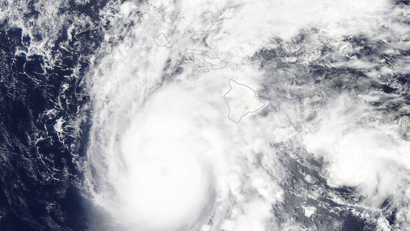
A week ago, the National Hurricane Center declared the system that is now Hurricane Nolo to be dissipating and said it would not issue further advisories unless it regenerated. It regenerated. On Friday morning the same centre was warning that Nolo, now a hurricane with sustained winds near 85 mph and forecast to reach 140 mph, could produce "catastrophic life-threatening flooding and mudslides" on the Big Island of Hawaii this weekend, with rainfall totals of 15 to 30 inches widely and up to 35 inches in places.
The storm is not expected to make landfall. That is the detail that most needs explaining, because it is the reason the forecast is so severe rather than a reason for comfort. A hurricane that passes to the south of the Big Island at walking pace, dragging its rain bands across the island's windward slopes for two days, is a more dangerous thing for Hawaii than a fast hurricane that crosses the coast and leaves.
Where the storm is and where it is going
As of Friday morning Nolo was hundreds of miles from the islands, moving north-northeast at 5 mph, according to the Miami-based hurricane centre. Hurricane-force winds extended 40 miles from its core and tropical-storm-force winds 105 miles. The forecast has it slowing almost to a stop, then turning west and gaining forward speed on Saturday and Sunday while continuing to strengthen over warm water. The centre expects it to become a major hurricane on Saturday; the forecast discussion allows for winds topping out around 140 mph within 72 hours, which is Category 4.
A hurricane watch is in effect for Hawaii County, meaning hurricane conditions are possible within 24 to 36 hours, alongside a tropical storm warning for the same county. Maui County is under a tropical storm watch. The centre said tropical-storm conditions were expected to begin in the warning area by Friday night, with hurricane conditions possible by early Saturday, "particularly in areas of steep terrain." The state closed every state park on the Big Island from Thursday and on Maui from Friday.
The rainfall map is sharply uneven. The eastern and southern Big Island, the windward side facing the storm, is forecast to receive 15 to 30 inches with 35 possible in spots. The island's western side is forecast at 5 to 8 inches with 10 at most. Maui is expected to see 4 to 8 inches with up to 15 in places, and the rest of the state 1 to 3 inches with isolated totals of 6. Each of those tiers, the centre said, is enough for life-threatening flooding and mudslides where the ground is steep.
Why a slow storm that misses is the dangerous case
Hilo is the wettest city in the United States for a reason that has nothing to do with hurricanes. Its two volcanoes, Mauna Kea and Mauna Loa, rise nearly 14,000 feet from the sea, and any moist air pushed against their eastern flanks is forced upward, cools and dumps its water. The town, on that coast, averages well over 100 inches of rain a year in ordinary trade-wind weather. A hurricane parked to the south sends a firehose of tropical moisture at those same slopes, and the mountains do the rest.
Speed is the multiplier. A hurricane's total rainfall at any point on the ground is roughly its rain rate multiplied by the time it spends overhead. Nolo at 5 mph, with a forecast pause before it turns, will spend a long time in the same place. That is the mechanism that turned Hurricane Harvey's stall over Houston in 2017 into 60 inches of rain, and it is the mechanism Hawaii has seen before.
Hurricane Lane in August 2018 is the precedent forecasters have in mind. Lane, too, was a powerful storm that stalled south of the islands and never made landfall. It dropped 52.02 inches of rain at Mountain View on the Big Island, the highest single-storm total in Hawaii's history and, at the time, the second highest ever measured in the United States after Harvey. Hilo airport recorded 36.76 inches, its wettest four-day stretch since 1949. The damage was almost entirely from water: flooded neighbourhoods, landslides on the Hamakua coast, roads severed by swollen streams. The wind, the thing people picture when they hear the word hurricane, barely reached the shore.
This rainfall could produce catastrophic life-threatening flooding and mudslides, especially in areas of steep terrain.
That is the hurricane centre's public advisory, and the phrase "steep terrain" carries the weight. A flood on flat ground rises; a flood on a volcano's flank moves, and it takes the slope with it. Mudslides and debris flows on saturated volcanic soil are what kill in Hawaiian rain events, and the eastern Big Island, from Hilo south through Puna and around to Kaʻū, is exactly the terrain the advisory describes.
A season that has already hit Hawaii twice
Nolo is arriving on ground that has not dried out. Hurricane Lala passed just south of the Big Island on August 15 as a Category 1 storm and brought rainfall totals above 20 inches to parts of the island, according to NASA's Earth Observatory. At least one person died, roughly 100 homes were damaged or washed away, and six bridges in the Kaʻū district were destroyed or nearly so, according to Honolulu Civil Beat and NBC News. Some power outages, Civil Beat reported, were expected to last months.
Then, on the night of September 7, Hurricane Lowell struck Kauaʻi at the other end of the chain with 90 mph winds, lifting a home off its foundation on the south shore, carrying cars across a hotel parking lot and knocking out power to 33,000 of the island's 36,000 electricity customers, according to Kauai County and Civil Beat. Three hurricanes affecting Hawaii in six weeks is extraordinary for a state that in most years sees none make a close approach.
The reason is in the water. The eastern Pacific is in the grip of a powerful El Niño, which warms the ocean along the storms' track toward Hawaii and has already produced three Category 5 hurricanes this season, Genevieve, Lowell and Polo. On Friday morning satellite imagery showed three hurricanes spinning at once: Nolo near Hawaii, Odalys over open water to the east, and Polo threatening Baja California Sur. Warm water is what allowed a system declared dead to come back, and it is what the forecast expects to feed Nolo through the weekend.
What makes this one hard to forecast
Nolo's track has been erratic. Earlier in the week it was heading west across open ocean when it took, in NPR's description, an abrupt right-hand turn north, directly toward the Big Island. The forecast now bends it back to the west. Each of those turns moves the rainfall maximum, and a shift of 50 miles in where the storm pauses is the difference between 35 inches on Puna and 35 inches at sea. The hurricane centre's cone is a statement of probability, and slow, weak-steering storms are the ones that wander out of it.
The counter-argument is that the forecast may be too pessimistic, as Lowell's was. Civil Beat's own headline on Kauaʻi after Lowell was that the island was hit hard "but worst fears averted." Rainfall forecasts of 30 inches are upper-bound statements, and Oʻahu's closures during Lane in 2018 were followed by far less rain there than had been forecast. A storm that stays far enough south, or moves faster than expected, could leave the western half of the forecast unused.
That argument would be more persuasive if the ground were dry and the emergency systems were rested. They are not. The Big Island is six weeks past Lala, with bridges down and outages unrepaired; a second 20-inch event on the same slopes will find the soil already saturated and the streams already scoured. The margin that let Kauaʻi absorb Lowell does not exist on the Kaʻū coast this weekend.
The durable point is the one Lane taught in 2018 and Lala repeated in August: in Hawaii, the hurricane that matters is the one that stops, not the one that lands. Nolo's forecast track keeps it offshore. Its forecast speed keeps it there for days. Whichever way the rainfall numbers finally land, the state is about to find out, for the third time since mid-August, what a slow storm does to a steep island.
This report is based on the National Hurricane Center's public advisory and forecast discussion for Hurricane Nolo as of Friday morning Hawaii time, as reported by NPR and CBS News; statements from the Hawaii Department of Land and Natural Resources; NASA Earth Observatory, Honolulu Civil Beat, NBC News and Kauai County reporting on Hurricanes Lala and Lowell; and National Weather Service records for Hurricane Lane in 2018. Hurricane forecasts are revised every six hours and Nolo's track has already changed repeatedly; the rainfall figures cited are the forecast ranges as of Friday, not observed totals.