
Nor’easter floods the New Jersey, New York and Boston coasts, killing one man in Brooklyn and cutting power to 100,000 — a rare September storm on a full moon pushed Ocean City’s tide to 7.63 feet, just shy of Winter Storm Jonas
The weekend's nor'easter was not a hurricane and its winds were not historic, yet it pushed Jersey Shore tides to near-record heights, killed a man in Brooklyn and knocked out power to about 100,000 customers. The explanation lies in timing: a slow storm, a full moon and trees still in full leaf.
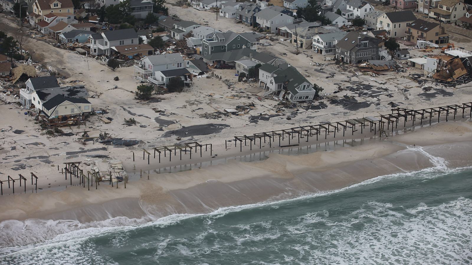
The most telling number from the nor'easter that has soaked the US East Coast since Friday is not a wind gust or a rainfall total. It is a tide reading. On Saturday morning, officials in Ocean City, New Jersey, said the water there reached 7.63 feet, according to the Philadelphia Inquirer, a hair below the 7.66 feet recorded during Winter Storm Jonas in 2016. Brigantine's mayor called it the worst tidal flooding since Superstorm Sandy, the Inquirer reported, citing the Press of Atlantic City. A storm that forecasters never classified as a hurricane produced water levels that coastal towns measure against their worst memories.
As of Sunday, the storm has been linked to at least one death. Leighton Brown, a 56-year-old New York City Housing Authority employee, was killed when a tree fell on him in a parking lot at the Cypress Hills Houses in Brooklyn on Saturday afternoon, according to the NYPD, NYCHA and Mayor Zohran Mamdani, as reported by CBS News, ABC News and the Associated Press. A swimmer reported missing off Fire Island on Saturday was later found alive, state police told CBS News.
Power outages peaked at about 100,000 customers across the mid-Atlantic and New England on Saturday, the AP reported. By Sunday morning, more than 40,000 customers in New York and about 30,000 in Connecticut were still without electricity, CBS News reported, citing PowerOutage.us, and the Inquirer counted more than 34,000 outages in New Jersey early Sunday afternoon. Both New York Gov. Kathy Hochul and New Jersey Gov. Mikie Sherrill declared states of emergency, Sherrill's covering eight counties.
What a nor'easter actually is
The name describes the wind, not the storm's structure. The National Weather Service defines a nor'easter as a storm along the East Coast of North America whose winds over the coastal area typically blow from the northeast. The agency says such storms usually develop between Georgia and New Jersey, within about 100 miles of the coast. Their fuel is contrast: cold air over the continent meeting air warmed over the Gulf Stream.
That is exactly the geometry this storm adopted. At 9 a.m. Eastern on Saturday its centre sat roughly 200 miles east of the Delmarva Peninsula, according to a Washington Post analysis republished by the Spokesman-Review, which meant winds along most of the seaboard were blowing from the east or northeast, straight onshore. The Post said the centre was parked over Gulf Stream water at its warmest of the year, 75 to 78 degrees Fahrenheit, and that the system was developing a pinched-off pocket of warm air at its core, known as a warm seclusion, rather than turning tropical.
The storm also refused to hurry. The AP described it as slow-moving, and CBS News reported it was expected to turn back toward the New Jersey coast Saturday night and could stall or meander nearby through Monday before departing on Tuesday. A fast storm pushes water ashore for one tide. A slow one does it for several, and Weather.com reported that persistent winds had already been piling ocean and bay water against the coast since Wednesday, when minor to moderate flooding was reported from the Jersey Shore to southeast Virginia.
The tide did the damage the wind could not
Coastal flooding is arithmetic. NOAA's National Ocean Service separates storm surge, the rise in water caused by wind pushing the sea ashore, from storm tide, which is that surge added on top of the normal astronomical tide. The astronomical tide peaks around new and full moons, when the sun, moon and Earth line up, which is why NOAA says the highest storm tides are often seen when a storm coincides with one.
This one did. The September full moon fell at 12:49 p.m. Eastern on Saturday, according to Space.com, and Hochul warned at a news conference that the full moon could push tides higher still, ABC News reported. The surges themselves were modest by hurricane standards: seas ran 2.6 feet above normal at Montauk and more than 3 feet at Atlantic City, the Washington Post reported. Stacked on a full-moon tide and repeated over several cycles, that was enough. In Freeport, on Long Island, high tide reached 7.8 feet, the highest in more than two years, and a gauge in Ocean County, New Jersey, reached 5.7 feet, the third highest on record, according to ABC News.
The National Weather Service had warned of exactly this. Its advisory, quoted by CBS News and the Washington Post, told residents to "prepare immediately for significant inundation in low-lying areas near the shore," with "repeated rounds of flooding" expected around high tide.
"Anyone who goes in or near the water this weekend is literally gambling with their life," New York Gov. Kathy Hochul said on Saturday, according to the Associated Press and ABC News.
Why September made it worse
The Washington Post analysis put the storm's rarity plainly: fewer than 2 percent of nor'easters form in September, with most arriving deeper into autumn and winter. The timing mattered less for the ocean than for the trees. Matthew Belk, a meteorologist at the weather service office in Norton, Massachusetts, told the AP that because leaves are still on the branches, trees catch more wind, raising the risk of broken limbs, power outages and blocked roads.
The results are visible in the damage reports. New York City received more than 900 reports of damaged or fallen trees from Friday afternoon, according to the city's parks department as cited by the AP, which noted some were duplicates. PSEG Long Island said it had restored more than 93,700 customers, with more than 18,500 still dark, ABC7 New York reported on Sunday. Peak gusts reached 74 mph in Surf City, New Jersey, and 81 mph at Montauk Point, CBS News and Weather.com reported, citing the weather service.
The 1991 Halloween nor'easter, later called the Perfect Storm, left about 38,000 people without power, a total its records attribute partly to leaves already being off the trees, and its highest tides came during a neap tide, when tidal ranges are smallest. This weekend's storm had the opposite luck on both counts: a full moon and a full canopy.
Flights: disruption, not paralysis
Air travel absorbed the storm better than it often does. About 200 flights in and out of Boston Logan were cancelled on Sunday, roughly 15 percent of the day's schedule, after about 260 on Saturday, CNBC reported, citing FlightAware. Fox Weather, also citing FlightAware, counted more than 3,000 delays and more than 400 cancellations nationwide on Saturday.
CNBC noted that airlines, which often cancel large parts of their schedules ahead of hurricanes or winter storms to keep crews and aircraft in position, kept most flights running this time. American, United, Delta and JetBlue said customers could move flights touching New York-area airports, Boston and smaller New England airports without a change fee or fare difference if they could travel before the middle of next week, according to CNBC.
The case that this was an ordinary storm
There is a reasonable argument that the weekend was a routine fall event amplified by coverage. The National Weather Service says nor'easters can occur any time of year and are most frequent and most violent between September and April, so a September storm is early rather than freakish. A spokesperson for the Steamship Authority serving Martha's Vineyard and Nantucket told the AP the cancellations were "not out of the realm of ordinary." Weather.com noted that the rain arrived spread over several days rather than in one deluge, limiting inland flash flooding to traditional trouble spots.
The scale comparison also cuts that way. The October 2021 nor'easter left more than 600,000 customers without power at its height and produced a 113 mph gust in Truro, Massachusetts, according to records compiled from NOAA and utility reports. This storm's outage peak was about a sixth of that. By Sunday, the weather service's Ray Kruzdlo told the Inquirer he did not expect a repeat of Saturday's highest tides, even as officials warned of further flooding at Monday morning's high tide and water that could take days to recede.
But the ordinary-storm reading misses where the harm concentrated. The wind was the headline; the water was the damage. Manasquan and Point Pleasant issued voluntary evacuations and Sea Bright urged low-lying residents to leave, and Manasquan's mayor warned that water could stay in the streets for a long time, according to the Washington Post and the AP. On Massachusetts' South Shore, CBS News reported that some seawalls protecting Scituate and Cohasset are mid-repair or have stalled because of federal funding cuts.
The durable lesson is that coastal flood risk on the Eastern Seaboard is increasingly a question of stacking rather than strength. A storm does not need hurricane winds to rival Sandy-era tides on the Jersey Shore. It needs onshore wind that lasts through several tide cycles, a full or new moon underneath it, and defences that are already stretched. This weekend supplied all three, in a month when few people were watching for a nor'easter at all.
This analysis rests on reporting by CBS News, the Associated Press (via NBC News and CBS), ABC News, ABC7 New York, NPR, the Washington Post (via the Spokesman-Review), the Philadelphia Inquirer, Weather.com, Fox Weather and CNBC, plus National Weather Service and NOAA explanatory material and Space.com's lunar data. Outage, cancellation, tide and injury figures are as of Sunday, September 27, and are provisional; damage totals were not yet available, and New Jersey officials said the full scope would not be clear until the storm departs. The 1991 and 2021 storm comparisons draw on published storm summaries compiled from NOAA and National Hurricane Center records. The hero image shows Hurricane Sandy in 2012, not this storm.