
Ross Fire grows to 80,000 acres in North Texas, the state's largest wildfire of the year — evacuations lifted as containment reaches 12%
A fire that started at 25 acres on Monday afternoon exploded across Palo Pinto and Jack counties within hours, burning a 97-year-old Scout camp, closing U.S. 180 and forcing hundreds of families from their homes about 60 miles west of Fort Worth. A weak front brought the first break on Wednesday — but no rain is coming.
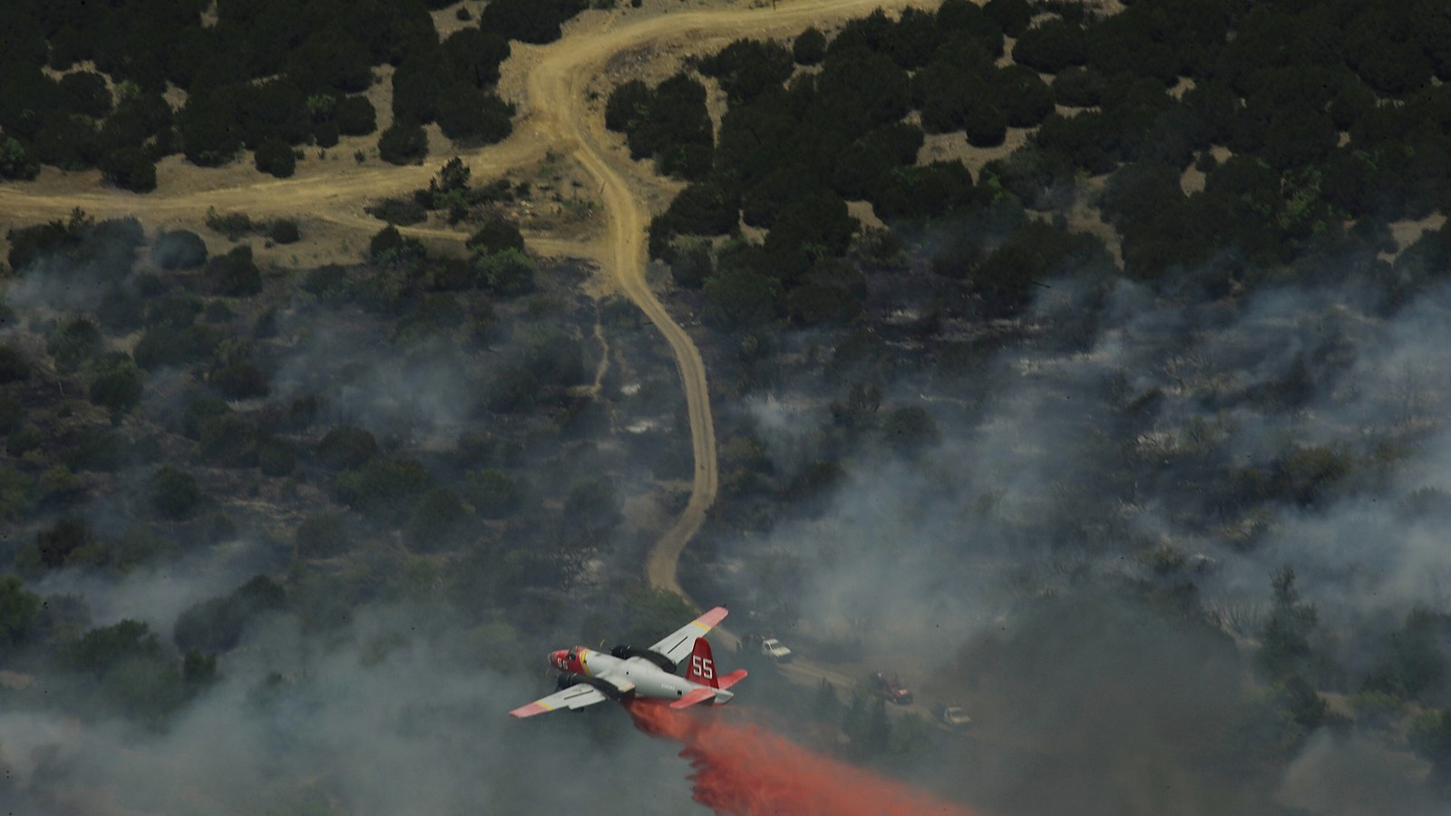
The Ross Fire was reported at roughly 25 acres just before 1:30 on Monday afternoon, burning along U.S. Highway 180 in central Palo Pinto County, about 60 miles west of Fort Worth. Within twelve hours it had consumed 18,000 acres. By 3 a.m. Tuesday it had crossed north into Jack County. By Wednesday morning, the Texas A&M Forest Service put it at an estimated 80,000 acres — 125 square miles — making it the largest wildfire Texas has seen this year, bigger than every other major fire of the 2026 season combined.
At one point on Monday, the fire doubled in size in roughly an hour. It jumped creeks and rivers as if they were not there, and embers thrown ahead of the front ignited spot fires as much as a mile in advance of the main blaze — the mechanism that makes a wind-driven grass fire effectively impossible to outflank.
The fuel load and the weather conditions, it's kind of been the perfect storm where we just haven't been able to contain it. We're throwing everything at this. — Danny Watkins, chief, Palo Pinto County Emergency Services District
Two days of retreat, one morning of relief
The human geography of the fire is ranch country: Palo Pinto, Graford, Jacksboro and the small communities strung along the Brazos River valley. About 630 homes were evacuated at the fire's peak, according to the governor's office, with a mandatory evacuation order Tuesday covering southern Jack County — residents along FM 2210 east toward U.S. 281, the Halsell Ranch Road area, and homes near Bartons Chapel. Evacuees were directed to the Twin Lakes activity center in Jacksboro. Graford, Bryson and Perrin-Whitt schools cancelled classes; U.S. 180 was closed along the fire front, one of seven road closures at the peak, and the FAA imposed a flight restriction over the area.
On Wednesday morning came the first genuinely good news of the week: evacuation orders were lifted as a weak cold front moved through, easing the winds that had driven the fire for two days. Containment, which stood at 5 per cent on Tuesday morning, reached 12 per cent by Wednesday. No deaths or injuries had been reported.
The property toll is real but, so far, remarkably small for a fire this size — at least five structures destroyed, by the count of the Texas A&M Forest Service and local officials. The most painful loss is Worth Ranch, the 97-year-old Scouting America camp near Palo Pinto, where many buildings burned. The camp's ranger, Pat Adams, evacuated safely, and no Scouts or guests were on site. Near Graford, a fifth-generation family canoe-rental business lost its office, repair shop, buses and trailers, and a century-old family home burned.
"It just took off way too fast," said Katie Rochelle, who evacuated as the fire approached the family business. "The wind was going in a tornado motion. I don't know how our house survived. Now we're waiting and praying."
The evacuation had a distinctly rural texture. The Humane Society of North Texas coordinated animal rescues, with a dozen dogs and 26 cats expected at the Mineral Wells shelter on Wednesday, while the Graham Livestock Commission threw open pens at the old Mineral Wells sale barn for evacuated cattle and horses. In ranch country, getting the animals out is not an afterthought of an evacuation — it is half the evacuation.
Why it exploded
The Ross Fire is not a mystery; it is arithmetic. The area around Palo Pinto has gone more than a month without measurable rain. Seventy-seven per cent of Texas is now in drought — a 20-point jump in a single week — and Dallas, San Antonio and Waco are all having their driest start to August on record, with no rain at all since the month began. The Forest Service describes the region's grasses and brush as critically to extremely dry. Add triple-digit heat and steady southerly winds gusting near 20 miles an hour, and a roadside ignition becomes an 80,000-acre fire in under two days. The cause remains under investigation.
The state's response scaled almost as fast as the fire. More than a hundred firefighters were on the ground by Tuesday morning and growing, backed by strike teams from the Texas Intrastate Fire Mutual Aid System, Forest Service dozers and motor graders, large air tankers, single-engine tankers and helicopters — including Texas National Guard Black Hawks and Chinooks dropping water on the front. Governor Greg Abbott announced Tuesday that FEMA had approved a Fire Management Assistance Grant, making Texas eligible for 75 per cent federal reimbursement of firefighting costs. "Texas will provide all necessary resources to protect Texans from the Ross Fire in Palo Pinto and Jack Counties," Abbott said.
The federal grant is worth being precise about: a Fire Management Assistance Grant reimburses suppression costs — the medics, ambulances, aircraft and overtime now flowing into two counties — but it is not a major disaster declaration, and it puts no money in the hands of families who lost buildings. Alongside the firefighting force, the state has deployed emergency medical task forces from the health department, Texas Highway Patrol troopers for road closures and traffic control, transportation crews, and monitors watching the utility and natural-gas infrastructure that threads through the fire area.
The Forest Service, which flagged the fire's "large growth potential" and "extreme fire behavior" early, has the state at Preparedness Level 3. Burn bans are in force in both counties, and smoke from the fire was visible across the Dallas-Fort Worth metroplex on Wednesday, where regulators declared an Ozone Action Day.
The shadow of Smokehouse Creek
Every large Texas grass fire now gets measured against one yardstick: Smokehouse Creek, the February 2024 monster that burned nearly 1.06 million acres of the Panhandle — the largest fire in Texas history and the second-largest ever recorded in the United States. The Ross Fire is about one-thirteenth that size. But the dynamic is identical: months of cured, drought-dried grass, sustained wind, and growth measured in tens of thousands of acres per day. Smokehouse Creek went from 40,000 acres to a million in roughly three days. That is the scenario the Wednesday wind shift appears — for now — to have taken off the table.
Before this week, the biggest fire of the Texas year had been May's Hunggate Fire in the Panhandle, at about 34,000 acres. The season's roughly 15 major fires had burned a combined 76,500 acres. The Ross Fire passed that total on its second day.
A national fire map with too many pins
Texas is burning in a crowded field. The Associated Press counts more than 50,000 wildfires across the United States so far in 2026 — the most in a decade. In Nevada, the Hawk Fire that ignited on the northwest edge of Reno over the weekend forced some 42,000 people from their homes at its peak and destroyed at least 47 houses before crews pushed containment to 85 per cent on Wednesday; investigators suspect it was human-caused. Washington State is enduring its third-worst fire season on record, with roughly 800,000 acres burned across 15 large fires.
What the pins on that map share is the setup, not the spark. Igntions are constant — power lines, vehicles, lightning, carelessness. What has changed is the receptiveness of the ground: longer dry spells, hotter shoulder seasons, and fuel that cures earlier and stays flammable later. North Texas in late August 2026 — a month without rain, in a state three-quarters covered by drought — is about as receptive as ground gets.
What happens next
The immediate forecast helps at the margins and solves nothing. Wednesday's front brought lighter winds and a slim chance of isolated storms, but highs stay near 100 degrees and no meaningful rain is expected in the coming days. Fire officials will use the lull to cut and strengthen containment lines; the risk is a wind shift that finds the 88 per cent of the perimeter still open.
For the families filtering back into southern Jack County on Wednesday, the ledger is mixed: homes largely standing, livelihoods scorched, a Scout camp that served North Texas for nearly a century partly in ash — and a fire season, statewide and national, that is nowhere near finished. The grass is still dry. The next ignition is only a matter of where.
Sources: Texas A&M Forest Service, Office of the Texas Governor, CBS News Texas, the Associated Press, Fox Weather, KERA, WBAP and ABC News. Figures as reported Wednesday morning, August 26, 2026; acreage and containment numbers change quickly on active fires.